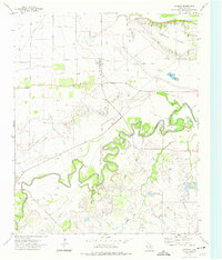
1972 Map of Charlie
USGS Topo · Published 1975About this map
Charlie serves as the primary settlement on this Clay County landscape, where the meandering course of the Wichita River dictates the local topography. This early 1970s survey illustrates a rural economy deeply tied to both natural resources and energy extraction, characterized by numerous oil wells and extensive pipelines that crisscross the terrain. The northern portion of the map is dominated by the elevated Pumpkin Ridge, while the river lowlands feature complex oxbows and marshy areas near Byers Lake. Genealogical researchers can locate a local Cem near the town center, while infrastructure markers like a WT (water tower), Water Tank, and a Gaging Sta along the river reflect the technical management of this arid ranching and oil-producing region. To the east, the Petrolia Reservoirs and the drainage of Hay Creek provide critical water management for the surrounding oil field operations.
Find a feature on this map
16 named features on this map. Tap any name to fly to it.
Don’t see what you’re looking for? This feature index may not catch every label — zoom into the map to look around manually.
Map Details
Editions of this 1972 Charlie Map
This is the sole edition of this map. No revisions or reprints were ever made.
Other maps of this area

1954 · Wichita Falls
USGS Topo · 1:250,000

1955 · Lawton
USGS Topo · 1:250,000

1956 · Henrietta
USGS Topo · 1:62,500

1957 · Hastings
USGS Topo · 1:62,500

1957 · Randlett
USGS Topo · 1:62,500

1957 · Wichita Falls East
USGS Topo · 1:62,500

1957 · Wichita Falls East
USGS Topo · 1:24,000

1958 · Wichita Falls
USGS Topo · 1:250,000
1972 · Dean
USGS Topo · 1:24,000
1972 · Thornberry
USGS Topo · 1:24,000