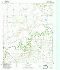
1991 Map of Charlie
USGS Topo · Published 1995About this map
The settlement of Charlie serves as the focal point for this northern Texas landscape, situated near the meandering path of the Wichita River. This late-twentieth-century study reveals a rural economy heavily defined by resource extraction and water management, where numerous Oil Field labels and scattered oil wells dominate the southern and central sections of the quadrangle. The terrain rises to the north at Pumpkin Ridge, while the eastern portion is marked by the Petrolia Reservoirs and the drainage of Hay Creek. Local infrastructure is captured in detail, from a Water Tank and Storage Bin near the town center to a small Cem and a Gaging Sta along the riverbank. This map provides researchers with a clear view of the region's industrial footprint and hydrology, showing how petroleum production and water storage shaped the environment within Clay County.
Find a feature on this map
13 named features on this map. Tap any name to fly to it.
Don’t see what you’re looking for? This feature index may not catch every label — zoom into the map to look around manually.
Map Details
Editions of this 1991 Charlie Map
This is the sole edition of this map. No revisions or reprints were ever made.
Other maps of this area

1954 · Wichita Falls
USGS Topo · 1:250,000

1955 · Lawton
USGS Topo · 1:250,000

1956 · Henrietta
USGS Topo · 1:62,500

1957 · Hastings
USGS Topo · 1:62,500

1957 · Randlett
USGS Topo · 1:62,500

1957 · Wichita Falls East
USGS Topo · 1:62,500

1957 · Wichita Falls East
USGS Topo · 1:24,000

1958 · Wichita Falls
USGS Topo · 1:250,000
1972 · Dean
USGS Topo · 1:24,000
1972 · Thornberry
USGS Topo · 1:24,000