
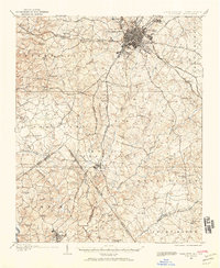
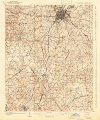
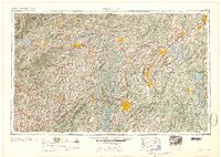
1941 Map of Charlotte
USGS Topo · Published 1941About this map
Charlotte is shown as a primary rail and transportation hub just as the region entered the early 1940s, with the Southern, Norfolk Southern, and Seaboard railroads all converging in the city center. This provisional survey, prepared by the 30th Engineer Battalion, detail the transition from the urban core to the surrounding farming communities and crossroads. Beyond the city limits, early residential developments like Meyers Park and industrial areas such as Chadwick-Hoskins are visible alongside established landmarks like Alexanders Store.
Find a feature on this map
49 named features on this map. Tap any name to fly to it.
Don’t see what you’re looking for? This feature index may not catch every label — zoom into the map to look around manually.
Map Details
Editions of this 1941 Charlotte Map
This is the sole edition of this map. No revisions or reprints were ever made.
Historical Maps of Eden Gardens Through Time
9 maps found
1905 Charlotte
Mecklenburg County, NC
1907 Charlotte
Mecklenburg County, NC
1941 Charlotte
Mecklenburg County, NC
1942 Charlotte
Mecklenburg County, NC
1953 Charlotte
Mecklenburg County, NC
1954 Charlotte
Mecklenburg County, NC

1960 Charlotte
Mecklenburg County, NC

1962 Charlotte
Mecklenburg County, NC
1985 Charlotte
Mecklenburg County, NC