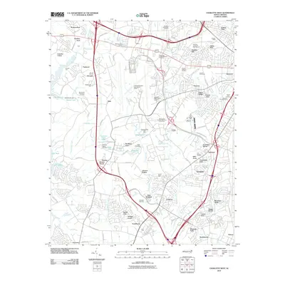
2010 Map of Charlotte West
USGS Topo · Published 2010About this map
Charlotte/Douglas International Airport dominates the central landscape of this western Mecklenburg County study, surrounded by a dense network of suburban developments and long-standing community landmarks. The area maintains deep ties to its congregational history through numerous burial grounds, including the Mount Olive Presbyterian Cemetery, Berryhill Presbyterian Cemetery, and Moores AME Zion Cemetery. These sites are interspersed among residential clusters like Westmoreland and Huntlynn Acres. To the west, the shoreline of Lake Wylie and Waddell Lake provide a sharp contrast to the industrial and commercial corridors near the Charlotte Coliseum. The landscape reflects a transition from agricultural roots, evidenced by the Hunters Dairy Farm, to a modern transportation and infrastructure hub, where smaller settlements like Dixie and Shopton sit adjacent to major thoroughfares and aviation facilities.
Find a feature on this map
125 named features on this map. Tap any name to fly to it.
Don’t see what you’re looking for? This feature index may not catch every label — zoom into the map to look around manually.
Map Details
Editions of this 2010 Charlotte West Map
This is the sole edition of this map. No revisions or reprints were ever made.
Other maps of this area

1905 · Charlotte
USGS Topo · 1:48,000

1907 · Charlotte
USGS Topo · 1:62,500

1914 · Gastonia
USGS Topo · 1:48,000

1916 · Gastonia
USGS Topo · 1:62,500

1941 · Charlotte
USGS Topo · 1:125,000

1942 · Charlotte
USGS Topo · 1:125,000

1947 · Clover
USGS Topo · 1:62,500

1948 · Paw Creek
USGS Topo · 1:24,000

1948 · Derita
USGS Topo · 1:24,000

1948 · Charlotte East
USGS Topo · 1:24,000