1976 Map of Charlotte West
USGS Topo · Published 1978About this map
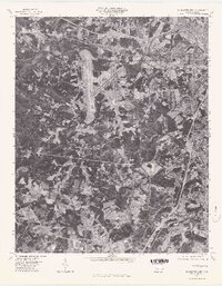
Charlotte's westward expansion is captured in this mid-1970s orthophoto, showing the transformation of the Mecklenburg County landscape into a major metropolitan hub. The most prominent feature is the massive airfield infrastructure of the city's primary airport, situated between the urban core and the southwestern outlying communities. This aerial perspective reveals the dense residential and industrial development pushing toward Dixie and Shopton, where traditional rural patterns meet the modern suburban grid. To the west, the winding shoreline of Lake Wylie provides a natural boundary, while the courses of Sugar Creek and Irwin Creek thread through the increasingly paved environment. The map offers an interpretive look at the region’s mid-century growth, highlighting how transportation and aviation corridors fundamentally reshaped the Piedmont landscape just before the final decades of the 20th century.
Find a feature on this map
6 named features on this map. Tap any name to fly to it.
Don’t see what you’re looking for? This feature index may not catch every label — zoom into the map to look around manually.
Map Details
Editions of this 1976 Charlotte West Map
This is the sole edition of this map. No revisions or reprints were ever made.
Other maps of this area

1905 · Charlotte
USGS Topo · 1:48,000

1907 · Charlotte
USGS Topo · 1:62,500

1914 · Gastonia
USGS Topo · 1:48,000

1916 · Gastonia
USGS Topo · 1:62,500

1941 · Charlotte
USGS Topo · 1:125,000

1942 · Charlotte
USGS Topo · 1:125,000

1947 · Clover
USGS Topo · 1:62,500

1948 · Paw Creek
USGS Topo · 1:24,000

1948 · Derita
USGS Topo · 1:24,000

1948 · Charlotte East
USGS Topo · 1:24,000