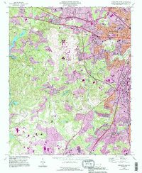
1993 Map of Charlotte West
USGS Topo · Published 1996About this map
Charlotte-Douglas International Airport serves as a dominant anchor in this portrait of Mecklenburg County during the 1990s, where urban expansion meets long-standing rural landmarks. The western reaches of Charlotte are defined by the convergence of major transit corridors like Wilkinson Boulevard and Interstate 77, which cut through a landscape formerly characterized by small communities and family farms. The map preserves the locations of vital community centers such as Steele Creek Ch and Central Steele Creek Ch, alongside the historic Berryhill Cem.
Find a feature on this map
63 named features on this map. Tap any name to fly to it.
Don’t see what you’re looking for? This feature index may not catch every label — zoom into the map to look around manually.
Map Details
Editions of this 1993 Charlotte West Map
This is the sole edition of this map. No revisions or reprints were ever made.
Other maps of this area

1905 · Charlotte
USGS Topo · 1:48,000

1907 · Charlotte
USGS Topo · 1:62,500

1914 · Gastonia
USGS Topo · 1:48,000

1916 · Gastonia
USGS Topo · 1:62,500

1941 · Charlotte
USGS Topo · 1:125,000

1942 · Charlotte
USGS Topo · 1:125,000

1947 · Clover
USGS Topo · 1:62,500

1948 · Paw Creek
USGS Topo · 1:24,000

1948 · Derita
USGS Topo · 1:24,000

1948 · Charlotte East
USGS Topo · 1:24,000