1939 Map of Charlottesville
USGS Topo · Published 1939About this map
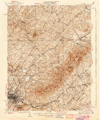
Charlottesville and the surrounding Piedmont landscape are captured here in the late 1930s, anchored by the iconic estate at Monticello and the industrial activity of the Chesapeake and Ohio and Southern Railway lines. The map reveals a deeply established social geography, showing prominent educational and medical institutions such as the Albemarle Training Sch, the Rosenwald Sch, and the Blue Ridge Sanatorium. Rural life is centered on small junctions and settlements like Barboursville, Ruckersville, and Stony Point, many of which developed along early corridors like the Spotswood Trail.
Find a feature on this map
80 named features on this map. Tap any name to fly to it.
Don’t see what you’re looking for? This feature index may not catch every label — zoom into the map to look around manually.
Map Details
Editions of this 1939 Charlottesville Map
3 editions found


Other maps of this area

1891 · Palmyra
USGS Topo · 1:125,000

1892 · Buckingham
USGS Topo · 1:125,000

1892 · Gordonsville
USGS Topo · 1:125,000

1892 · Harrisonburg
USGS Topo · 1:125,000

1895 · Palmyra
USGS Topo · 1:125,000

1897 · Palmyra
USGS Topo · 1:125,000

1929 · Covesville
USGS Topo · 1:62,500

1930 · Madison
USGS Topo · 1:48,000

1931 · University
USGS Topo · 1:62,500

1933 · Madison
USGS Topo · 1:62,500