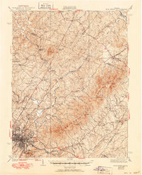
1939 Map of Charlottesville
USGS Topo · Published 1950About this map
Monticello sits prominently on its namesake mountain overlooking the growing city of Charlottesville and the South Fork Rivanna River. This survey, based on 1935 data with later revisions, shows the landscape of Albemarle County as it transitioned from its deep agricultural roots toward modern development. The presence of the Albemarle Training Sch and Rosenwald Sch provides essential evidence of the era's segregated educational landscape.
Find a feature on this map
87 named features on this map. Tap any name to fly to it.
Don’t see what you’re looking for? This feature index may not catch every label — zoom into the map to look around manually.
Map Details
Editions of this 1939 Charlottesville Map
3 editions found

Other maps of this area

1891 · Palmyra
USGS Topo · 1:125,000

1892 · Buckingham
USGS Topo · 1:125,000

1892 · Gordonsville
USGS Topo · 1:125,000

1892 · Harrisonburg
USGS Topo · 1:125,000

1895 · Palmyra
USGS Topo · 1:125,000

1897 · Palmyra
USGS Topo · 1:125,000

1929 · Covesville
USGS Topo · 1:62,500

1930 · Madison
USGS Topo · 1:48,000

1931 · University
USGS Topo · 1:62,500

1933 · Madison
USGS Topo · 1:62,500