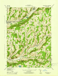
1945 Map of Charlotteville
USGS Topo · Published 1945About this map
The Delaware and Hudson railroad corridor and the winding waters of Schenevus Creek define the northern valley of this 1940s landscape, where rural communities like Worcester and East Worcester served as local hubs. This survey by the Tennessee Valley Authority and Army Corps of Engineers captures a high-elevation interior where the boundary between Otsego and Schoharie counties crosses through heavily wooded terrain. Numerous rural schoolhouses, such as Hollenbeck Sch and Center Valley Sch, are scattered along the narrow roads, reflecting a decentralized settlement pattern before the consolidation of rural districts.
Find a feature on this map
47 named features on this map. Tap any name to fly to it.
Don’t see what you’re looking for? This feature index may not catch every label — zoom into the map to look around manually.
Map Details
Editions of this 1945 Charlotteville Map
This is the sole edition of this map. No revisions or reprints were ever made.
Other maps of this area

1904 · Richmondville
USGS Topo · 1:62,500

1904 · Hobart
USGS Topo · 1:62,500

1907 · Cooperstown
USGS Topo · 1:62,500

1909 · Cooperstown
USGS Topo · 1:62,500

1909 · Delhi
USGS Topo · 1:62,500

1911 · Delhi
USGS Topo · 1:62,500

1943 · South Valley
USGS Topo · 1:24,000

1943 · Westford
USGS Topo · 1:24,000

1943 · Charlotteville
USGS Topo · 1:24,000
1943 · Schenevus
USGS Topo · 1:24,000