
1943 Map of Westford
USGS Topo · Published 1960About this map
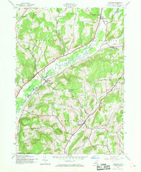
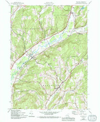
The winding course of Cherry Valley Creek dominates this mid-century topographic record of Otsego County, defining the valley that connects the rural settlements of Middlefield and Westford. Published for civil use by the U.S. Geological Survey based on 1942 aerial photography, the map reveals a landscape of upland farming and small crossroads communities. Notable for genealogists are the numerous district schools, including School No 7, School No 10, and School No 8, which were still active or recently converted at the time of the survey. The northeast corner is anchored by the community of Roseboom and the nearby Belvedere Lake, while smaller hamlets like Pleasant Brook and Maple Valley mark the intersections of early local road networks. The terrain, characterized by steep hills and hollows like Hubbell Hollow and Shellrock Creek, highlights the geographic isolation that preserved these rural patterns well into the 1940s.
Find a feature on this map
25 named features on this map. Tap any name to fly to it.
Don’t see what you’re looking for? This feature index may not catch every label — zoom into the map to look around manually.
Map Details
Editions of this 1943 Westford Map
3 editions found
Other maps of this area

1898 · Canajoharie
USGS Topo · 1:62,500

1900 · Canajoharie
USGS Topo · 1:62,500

1902 · Canajoharie
USGS Topo · 1:62,500

1903 · Richfield Springs
USGS Topo · 1:62,500

1904 · Richmondville
USGS Topo · 1:62,500

1907 · Cooperstown
USGS Topo · 1:62,500

1909 · Cooperstown
USGS Topo · 1:62,500

1943 · Milford
USGS Topo · 1:24,000

1943 · South Valley
USGS Topo · 1:24,000

1943 · Richfield Springs
USGS Topo · 1:24,000