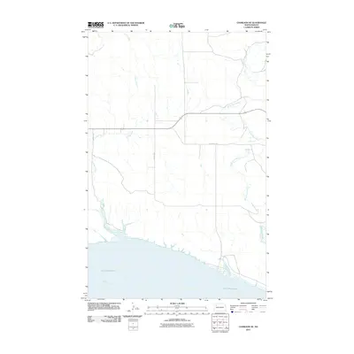
2011 Map of Charlson NE
USGS Topo · Published 2011About this map
Lake Sakakawea and the Missouri River dominate the southern landscape of this Williams County quadrangle. The terrain is defined by the drainage patterns of the White Earth River in the east and the winding course of Alkali Creek to the west, both of which flow toward the massive reservoir. The infrastructure reflects a rural grid, punctuated by routes like 102nd Ave NW and the evocative Old Scenic Hwy. The map provides a detailed view of the shoreline and the upland plateaus, showing how local transportation adapts to the northern North Dakota coulees and river valleys before they reach the impounded waters of the Missouri.
Find a feature on this map
7 named features on this map. Tap any name to fly to it.
Don’t see what you’re looking for? This feature index may not catch every label — zoom into the map to look around manually.
Map Details
Editions of this 2011 Charlson NE Map
This is the sole edition of this map. No revisions or reprints were ever made.
Other maps of this area

1953 · Williston
USGS Topo · 1:250,000

1957 · Williston
USGS Topo · 1:250,000

1965 · Charlson
USGS Topo · 1:24,000

1965 · Charlson SW
USGS Topo · 1:24,000

1965 · Charlson NE
USGS Topo · 1:24,000

1965 · Charlson NW
USGS Topo · 1:24,000

1979 · Tioga SE
USGS Topo · 1:24,000
1979 · Tioga SW
USGS Topo · 1:24,000

1981 · Manitou
USGS Topo · 1:24,000
1981 · Rat Lake
USGS Topo · 1:24,000