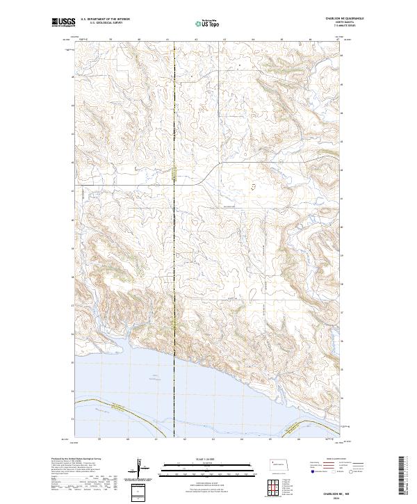
2024 Map of Charlson NE
USGS Topo · Published 2024About this map
Lake Sakakawea dominates the southern portion of this landscape, formed by the impoundment of the Missouri River. The shoreline reflects a complex geography where the river valley met the high plains, creating a rugged interface of inlets and coulees. Moving north, the terrain is defined by the drainage of the White Earth River and Alkali Creek, which cut through the prairie and reveal the underlying topography of the Williston Basin. This area sits at the junction of several county lines, including Williams, Mountrail, and McKenzie counties. A network of rural section roads and corridors like the Old Senic Hwy and Beaver Rd provide access through the townships of t155n r95w and t154n r94w, illustrating the enduring grid of the Public Land Survey System in this part of North Dakota.
Find a feature on this map
20 named features on this map. Tap any name to fly to it.
Don’t see what you’re looking for? This feature index may not catch every label — zoom into the map to look around manually.
Map Details
Editions of this 2024 Charlson NE Map
This is the sole edition of this map. No revisions or reprints were ever made.
Other maps of this area

1953 · Williston
USGS Topo · 1:250,000

1957 · Williston
USGS Topo · 1:250,000

1965 · Charlson
USGS Topo · 1:24,000

1965 · Charlson SW
USGS Topo · 1:24,000

1965 · Charlson NE
USGS Topo · 1:24,000

1965 · Charlson NW
USGS Topo · 1:24,000

1979 · Tioga SE
USGS Topo · 1:24,000
1979 · Tioga SW
USGS Topo · 1:24,000

1981 · Manitou
USGS Topo · 1:24,000
1981 · Rat Lake
USGS Topo · 1:24,000