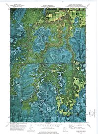
1973 Map of Chase Brook
USGS Topo · Published 1976About this map
Red Lake Indian Reservation lands meet the northern reaches of the Beltrami Island State Forest in this orthophotomap, which utilizes aerial imagery from 1969 to document the dense wetlands and forest cover of the region. The landscape is defined by the winding course of the Winter Rapid River and its confluence with Chase Brook, where the intricate patterns of the swampy terrain are clearly visible through the photographic base. A Winter Trail provides one of the few named routes through the dense vegetation, illustrating the seasonal nature of transportation in these northern woods during the early 1970s. The southern portion of the map transitions into the Red Lake State Wildlife Management Area, reflecting a mid-century emphasis on conservation and habitat management. This map is particularly useful for understanding the unchanged boundaries of tribal and state lands in Lake of the Woods County.
Find a feature on this map
9 named features on this map. Tap any name to fly to it.
Don’t see what you’re looking for? This feature index may not catch every label — zoom into the map to look around manually.
Map Details
Editions of this 1973 Chase Brook Map
This is the sole edition of this map. No revisions or reprints were ever made.
Other maps of this area

1919 · Peppermint Creek
USGS Topo · 1:62,500

1919 · G
USGS Topo · 1:62,500

1919 · Knutson
USGS Topo · 1:62,500

1921 · Baudette
USGS Topo · 1:62,500

1943 · Peppermint Creek
USGS Topo · 1:62,500

1954 · Roseau
USGS Topo · 1:250,000

1957 · Roseau
USGS Topo · 1:250,000

1958 · Roseau
USGS Topo · 1:250,000

1968 · Baudette SE
USGS Topo · 1:24,000
1968 · Graceton SE
USGS Topo · 1:24,000