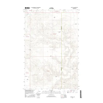
2017 Map of Chase Hill
USGS Topo · Published 2017About this map
Chase Hill and the surrounding high plains of North Central Montana are defined by a complex network of ephemeral drainages and flat-topped landforms. This survey illustrates the intricate topography of the region, where the primary waterway, Birch Cr, winds through a series of pronounced benches including Greens Bench, Golf Bench, and Cummings Bench. The map captures the boundary between Chouteau and Blaine counties, revealing a landscape etched by numerous coulees such as Pigtail Coulee, Coal Coulee, and Wolf Coulee. These features suggest a history of seasonal water erosion and land use focused on the accessible plateau surfaces above the breaks. The presence of named roads like Brewer Rd and Eskay Rd provides a record of rural access through these townships, while Birch Creek Hill serves as a prominent landmark in the southern reaches of the quadrangle.
Find a feature on this map
20 named features on this map. Tap any name to fly to it.
Don’t see what you’re looking for? This feature index may not catch every label — zoom into the map to look around manually.
Map Details
Editions of this 2017 Chase Hill Map
This is the sole edition of this map. No revisions or reprints were ever made.
Other maps of this area

1954 · P N Ranch
USGS Topo · 1:24,000

1954 · Gallatin Rapids
USGS Topo · 1:24,000

1954 · Council Island
USGS Topo · 1:24,000

1954 · Lewistown
USGS Topo · 1:250,000

1959 · Lewistown
USGS Topo · 1:250,000

1964 · Pigtail Coulee
USGS Topo · 1:24,000

1964 · Ragland Bench
USGS Topo · 1:24,000

1964 · Chase Hill
USGS Topo · 1:24,000
1984 · Eskay NE
USGS Topo · 1:24,000
1984 · Eskay NW
USGS Topo · 1:24,000