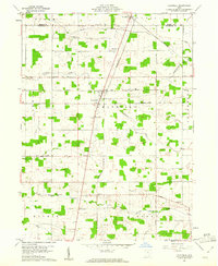
1960 Map of Chatfield
USGS Topo · Published 1961About this map
Agricultural fields and woodlots dominate the Crawford County landscape near Chatfield at the dawn of the 1960s. The village of Chatfield serves as a local hub, situated at the intersection of the Pennsylvania railroad and several primary roads, while smaller settlements like Carrothers and Ridgeton mark the rail corridors. This map reveals a high density of rural institutions, particularly churches such as North Union Ch, College Hill Ch, and Nazareth Ch, which often stand alongside early burial grounds like Windfall Cem and Buchman Cem. The local hydrology is defined by the winding paths of Silver Creek, Sycamore Creek, and the evocative Broken Sword Creek, which snake through the townships of Bloom, Venice, and Lykens. The geometric precision of the township boundaries and the grid-like road system, including County Line Road, reflect the enduring legacy of early land surveys in northern Ohio.
Find a feature on this map
33 named features on this map. Tap any name to fly to it.
Don’t see what you’re looking for? This feature index may not catch every label — zoom into the map to look around manually.
Map Details
Editions of this 1960 Chatfield Map
2 editions found
Other maps of this area

1906 · Sycamore
USGS Topo · 1:62,500

1906 · Tiffin
USGS Topo · 1:62,500

1915 · Siam
USGS Topo · 1:62,500

1915 · Bucyrus
USGS Topo · 1:62,500

1943 · Bucyrus
USGS Topo · 1:62,500

1950 · Marion
USGS Topo · 1:250,000

1956 · Toledo
USGS Topo · 1:250,000

1960 · North Robinson
USGS Topo · 1:24,000

1960 · Oceola
USGS Topo · 1:24,000
1960 · Bloomville
USGS Topo · 1:24,000
Featured Places
- Chatfield, Chatfield Township
- Lykens Township, OH
- Chatfield Township, OH
- Cranberry Township, OH
- Holmes Township, OH