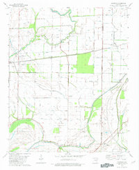
1981 Map of Chatfield
USGS Topo · Published 1982About this map
Blackfish Bayou and the winding course of Fifteenmile Bayou define this Mississippi Delta landscape along the border of St Francis and Crittenden counties. The map reveals a highly managed agricultural environment, where natural waterways are supplemented by an extensive network of ditches, flumes, and siphons designed to drain the fertile bottomlands. Small rural settlements like Stump City, Greasy Corner, and Democrat are scattered across the grid, reflecting the decentralized community structure of the early 1980s. Local social history is anchored by several country churches and burial grounds, including Travelers Rest Ch, St Mary Ch, and Mt Zion Cem. These points of assembly, along with the Landing Strip near Heth, illustrate the dual reliance on traditional community centers and modern agricultural aviation in this corner of Arkansas.
Find a feature on this map
25 named features on this map. Tap any name to fly to it.
Don’t see what you’re looking for? This feature index may not catch every label — zoom into the map to look around manually.
Map Details
Editions of this 1981 Chatfield Map
2 editions found
Other maps of this area

1931 · Horseshoe Lake
USGS Topo · 1:62,500

1939 · Horseshoe Lake
USGS Topo · 1:62,500

1939 · Park Place
USGS Topo · 1:62,500

1939 · Edmondson
USGS Topo · 1:62,500

1940 · Whitmore
USGS Topo · 1:62,500

1948 · Helena
USGS Topo · 1:250,000

1950 · Helena
USGS Topo · 1:250,000

1953 · Memphis
USGS Topo · 1:250,000

1954 · Horseshoe Lake
USGS Topo · 1:62,500

1954 · Edmondson
USGS Topo · 1:62,500