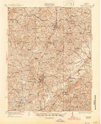
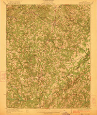
1923 Map of Chatham
USGS Topo · Published 1945About this map
Chatham serves as the central hub for this early 20th-century landscape, where the Southern railroad connects small rural communities like Elba and Whittles Sta. The terrain is defined by a dense network of country schools and family-run mills, such as Vaden's Mill and Motleys Mill, reflecting a self-sufficient agrarian economy. Notable industrial features include the Bennett Mine and Thompsons Mine, which are interspersed among dozens of local schools like Hazy Grove School and Kingwood School.
Find a feature on this map
114 named features on this map. Tap any name to fly to it.
Don’t see what you’re looking for? This feature index may not catch every label — zoom into the map to look around manually.
Map Details
Editions of this 1923 Chatham Map
3 editions found
Other maps of this area

1890 · Roanoke
USGS Topo · 1:125,000

1891 · Roanoke
USGS Topo · 1:125,000

1892 · Lynchburg
USGS Topo · 1:125,000

1921 · Chatham
USGS Topo · 1:48,000

1922 · Callands
USGS Topo · 1:48,000

1923 · Danville
USGS Topo · 1:48,000

1923 · Chatham
USGS Topo · 1:62,500

1924 · Draper
USGS Topo · 1:48,000

1924 · Callands
USGS Topo · 1:62,500

1925 · Danville
USGS Topo · 1:62,500