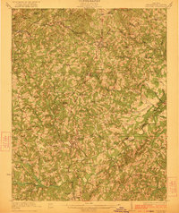
1923 Map of Chatham
USGS Topo · Published 1923About this map
Chatham serves as the central hub for this early twentieth-century survey of Pittsylvania County, situated at the intersection of a complex agrarian and industrial landscape. The Southern Railway and the Danville And Western Railway facilitate the movement of goods and people through several small depots and settlements, including Gretna and the uniquely named Tight Squeeze. The regional economy of the 1920s is clearly visible through the numerous water-powered mills such as Vaden's Mill and Hodnetts Mill lining the local waterways.
Find a feature on this map
108 named features on this map. Tap any name to fly to it.
Don’t see what you’re looking for? This feature index may not catch every label — zoom into the map to look around manually.
Map Details
Editions of this 1923 Chatham Map
3 editions found
Other maps of this area

1890 · Roanoke
USGS Topo · 1:125,000

1891 · Roanoke
USGS Topo · 1:125,000

1892 · Lynchburg
USGS Topo · 1:125,000

1921 · Chatham
USGS Topo · 1:48,000

1922 · Callands
USGS Topo · 1:48,000

1923 · Danville
USGS Topo · 1:48,000

1923 · Chatham
USGS Topo · 1:62,500

1924 · Draper
USGS Topo · 1:48,000

1924 · Callands
USGS Topo · 1:62,500

1925 · Danville
USGS Topo · 1:62,500