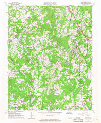
1965 Map of Chatham
USGS Topo · Published 1968About this map
Chatham serves as the focal point of this mid-1960s landscape, positioned as a center of education and agriculture in Pittsylvania County. The town is flanked by notable institutions such as the Hargrave Military Academy and Chatham Hall Sch, while the presence of the Virginia Polytechnic Institute Tobacco Research Station underscores the region's historical reliance on tobacco farming. To the south, the Banister River winds through the terrain, joined by tributaries like Cherrystone Creek and Pudding Creek.
Find a feature on this map
51 named features on this map. Tap any name to fly to it.
Don’t see what you’re looking for? This feature index may not catch every label — zoom into the map to look around manually.
Map Details
Editions of this 1965 Chatham Map
3 editions found
Other maps of this area

1921 · Chatham
USGS Topo · 1:48,000

1922 · Callands
USGS Topo · 1:48,000

1923 · Danville
USGS Topo · 1:48,000

1923 · Chatham
USGS Topo · 1:62,500

1924 · Draper
USGS Topo · 1:48,000

1924 · Callands
USGS Topo · 1:62,500

1925 · Danville
USGS Topo · 1:62,500

1926 · Draper
USGS Topo · 1:62,500

1944 · Draper
USGS Topo · 1:62,500

1944 · Callands
USGS Topo · 1:62,500