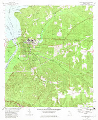
1982 Map of Chattahoochee
USGS Topo · Published 1983About this map
Chattahoochee sits at the vital junction where the Flint River and Apalachicola River meet at the head of Lake Seminole. This 1982 survey illustrates a landscape dominated by large-scale institutions and infrastructure, most notably the sprawling grounds of the State Hospital and the surrounding support facilities like the Filtration Plant and Sewage Disposal. The area’s role as a regional transit hub is clear, with the Seaboard and Seaboard Coast Line railroads intersecting near River Junction.
Find a feature on this map
61 named features on this map. Tap any name to fly to it.
Don’t see what you’re looking for? This feature index may not catch every label — zoom into the map to look around manually.
Map Details
Editions of this 1982 Chattahoochee Map
This is the sole edition of this map. No revisions or reprints were ever made.
Other maps of this area

1954 · Sneads
USGS Topo · 1:24,000

1954 · Tallahassee
USGS Topo · 1:250,000

1955 · Fairchild
USGS Topo · 1:24,000

1955 · Reynoldsville
USGS Topo · 1:24,000

1955 · Rock Bluff
USGS Topo · 1:24,000

1955 · Sycamore
USGS Topo · 1:24,000

1955 · Chattahoochee
USGS Topo · 1:24,000

1955 · Bainbridge
USGS Topo · 1:62,500

1955 · Mt Pleasant
USGS Topo · 1:24,000

1959 · Tallahassee
USGS Topo · 1:250,000