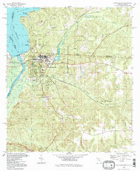
1994 Map of Chattahoochee
USGS Topo · Published 1998About this map
The confluence of the Flint River and the Apalachicola River anchors this geographic study of the Florida-Georgia border. Dominating the landscape is the sprawling Florida State Hospital complex and the massive Apalachee Correctional Institution acreage, which straddles the corporate boundary and the state line along the Watson Line. The city of Chattahoochee serves as a critical infrastructure hub, featuring the CSX Transportation rail line, a Filtration Plant, and River Junction Landing. Genealogical interest is found in numerous local burial grounds including River Hill Cem, Freeman Cem, and the specialized State Hospital Cem. The map illustrates a high concentration of institutional and industrial land use, marked by extensive claypits and the Sewage Disposal works, set against the natural backdrop of Lake Seminole and the winding Mosquito Creek.
Find a feature on this map
53 named features on this map. Tap any name to fly to it.
Don’t see what you’re looking for? This feature index may not catch every label — zoom into the map to look around manually.
Map Details
Editions of this 1994 Chattahoochee Map
This is the sole edition of this map. No revisions or reprints were ever made.
Other maps of this area

1954 · Sneads
USGS Topo · 1:24,000

1954 · Tallahassee
USGS Topo · 1:250,000

1955 · Fairchild
USGS Topo · 1:24,000

1955 · Reynoldsville
USGS Topo · 1:24,000

1955 · Rock Bluff
USGS Topo · 1:24,000

1955 · Sycamore
USGS Topo · 1:24,000

1955 · Chattahoochee
USGS Topo · 1:24,000

1955 · Bainbridge
USGS Topo · 1:62,500

1955 · Mt Pleasant
USGS Topo · 1:24,000

1959 · Tallahassee
USGS Topo · 1:250,000