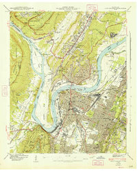
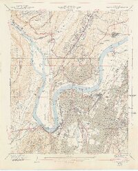
1941 Map of Chattanooga
USGS Topo · Published 1947About this map
Lookout Mountain and the Cumberland Escarpment frame this 1940s landscape, where the Tennessee River makes its dramatic loop around Moccasin Bend. This survey documents a critical period of urban expansion and industrial transit, featuring the Incline Railway ascending the heights above St Elmo and the Stringers Ridge Tunnel facilitating movement north. The city's social and institutional fabric is visible through landmarks like the University of Chattanooga, Erlanger Hospital, and the Pine Breeze Sanatorium. Along the river, the US Engr Dept Boat Yards and Citico Yards highlight the era's heavy reliance on rail and water transport. Genealogists will find significant detail in the various burial grounds, including the National Cem, Bnai Zion Cem, and the Missionary Cem on Missionary Ridge. Neighborhoods such as Lupton City and Alton Park appear as established hubs before the mid-century highway booms reshaped the local geography.
Find a feature on this map
140 named features on this map. Tap any name to fly to it.
Don’t see what you’re looking for? This feature index may not catch every label — zoom into the map to look around manually.
Map Details
Editions of this 1941 Chattanooga Map
5 editions found
Other maps of this area

1886 · Ringgold
USGS Topo · 1:125,000

1888 · Chattanooga
USGS Topo · 1:125,000

1892 · Ringgold
USGS Topo · 1:125,000

1893 · Chattanooga
USGS Topo · 1:125,000

1935 · East Chattanooga
USGS Topo · 1:24,000

1935 · Daisy
USGS Topo · 1:24,000

1935 · East Ridge
USGS Topo · 1:24,000

1936 · Ketner Gap
USGS Topo · 1:24,000

1936 · Hooker
USGS Topo · 1:24,000

1936 · Fort Oglethorpe
USGS Topo · 1:24,000