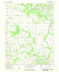
1968 Map of Chauncey
USGS Topo · Published 1970About this map
The Embarras River defines the eastern landscape of this southeastern Illinois region, where the Old Indian Boundary Treaty line still cuts a diagonal path across the rectilinear township sections. In the late 1960s, the rural character of Lawrence County is underscored by the Consolidated Oil and Gas Field, marked by numerous Oil Wells scattered across the flats. Small communities and gathering points like Chauncey, Port Jackson, and Petrolia anchor the local geography, alongside vanished or isolated social hubs such as the Petty Sch and Townhall. The map detail traces an intricate network of waterways including The Slough, Honey Creek, and Muddy Creek, which feed into the primary river valley. Family history is preserved through several rural burial grounds such as Waggoner Cem and Keplinger Cem, which remain as quiet landmarks of the area's agricultural settlement.
Find a feature on this map
32 named features on this map. Tap any name to fly to it.
Don’t see what you’re looking for? This feature index may not catch every label — zoom into the map to look around manually.
Map Details
Editions of this 1968 Chauncey Map
This is the sole edition of this map. No revisions or reprints were ever made.
Other maps of this area

1910 · Hardinville
USGS Topo · 1:62,500

1911 · Sumner
USGS Topo · 1:62,500

1913 · Sumner
USGS Topo · 1:62,500

1915 · Vincennes
USGS Topo · 1:62,500

1917 · Birds
USGS Topo · 1:62,500

1942 · Birds
USGS Topo · 1:62,500

1944 · Vincennes
USGS Topo · 1:62,500

1956 · Vincennes
USGS Topo · 1:250,000

1957 · Vincennes
USGS Topo · 1:250,000

1958 · Vincennes
USGS Topo · 1:250,000