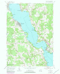
1954 Map of Chautauqua
USGS Topo · Published 1979About this map
Chautauqua Lake anchors this mid-century portrait of a celebrated summer destination, defined by the world-renowned Chautauqua Institution and its landmarks, including the Amphitheater and Bell Tower. Along the eastern and western shores, a dense network of lakeside communities such as Bemus Point, Dewittville, and Maple Springs reveals the area's growth as a recreational hub.
Find a feature on this map
68 named features on this map. Tap any name to fly to it.
Don’t see what you’re looking for? This feature index may not catch every label — zoom into the map to look around manually.
Map Details
Editions of this 1954 Chautauqua Map
3 editions found
Other maps of this area

1899 · Westfield
USGS Topo · 1:62,500

1900 · Dunkirk
USGS Topo · 1:62,500

1904 · Chautaqua
USGS Topo · 1:62,500

1905 · Clymer
USGS Topo · 1:62,500

1939 · Clymer
USGS Topo · 1:62,500

1941 · Chautauqua
USGS Topo · 1:62,500

1941 · Clymer
USGS Topo · 1:62,500

1943 · Dunkirk
USGS Topo · 1:62,500

1954 · Chautauqua
USGS Topo · 1:24,000

1954 · Ellery Center
USGS Topo · 1:24,000