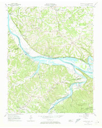
1957 Map of Cheatham Dam
USGS Topo · Published 1973About this map
Cheatham Lake and the Cumberland River dominate this mid-century landscape, where the newly constructed Cheatham Dam reshaped the local topography. This 1957 field-checked survey reveals a rural network of riverbank settlements and upland farms connected by the Central Tennessee Railroad. The map is particularly rich in community landmarks essential for family history research, including the Chapmansboro PO and small rural congregations like Bethel Ch, Clifton Ch, and Mt Liberty Ch.
Find a feature on this map
63 named features on this map. Tap any name to fly to it.
Don’t see what you’re looking for? This feature index may not catch every label — zoom into the map to look around manually.
Map Details
Editions of this 1957 Cheatham Dam Map
3 editions found
Other maps of this area

1930 · White Bluff
USGS Topo · 1:62,500

1933 · White Bluff
USGS Topo · 1:62,500

1956 · Nashville
USGS Topo · 1:250,000

1957 · Cheatham Dam
USGS Topo · 1:24,000

1957 · Pleasant View
USGS Topo · 1:24,000

1957 · Henrietta
USGS Topo · 1:24,000

1957 · Ashland City
USGS Topo · 1:24,000

1958 · Charlotte
USGS Topo · 1:24,000

1958 · Cumberland Furnace
USGS Topo · 1:24,000
1958 · Excell
USGS Topo · 1:24,000