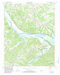
1957 Map of Cheatham Dam
USGS Topo · Published 1983About this map
The Cumberland River and Harpeth River define this landscape along the border of Cheatham and Dickson Counties. The construction of the Cheatham Dam dominates the central river valley, creating Lake Cheatham and altering the local hydrology. This 1957 survey, updated with 1981 aerial photography, captures the region's rural character through its concentration of small settlements like Bellsburg, Neptune, and Cheap Hill. Local life is anchored by community landmarks such as Millers Chapel Ch and its namesake school, Millers Chapel Sch, alongside several other country churches like Mt Zion Ch and Mt Liberty Ch. The map also reveals specialized land use within the Dyson Ditch Wildlife Refuge and the Waterfowl Harpeth Management Area, showing a transition from early farming towards managed conservation areas along the winding river bends like Johnson Bend.
Find a feature on this map
54 named features on this map. Tap any name to fly to it.
Don’t see what you’re looking for? This feature index may not catch every label — zoom into the map to look around manually.
Map Details
Editions of this 1957 Cheatham Dam Map
3 editions found
Other maps of this area

1930 · White Bluff
USGS Topo · 1:62,500

1933 · White Bluff
USGS Topo · 1:62,500

1956 · Nashville
USGS Topo · 1:250,000

1957 · Cheatham Dam
USGS Topo · 1:24,000

1957 · Pleasant View
USGS Topo · 1:24,000

1957 · Henrietta
USGS Topo · 1:24,000

1957 · Ashland City
USGS Topo · 1:24,000

1958 · Charlotte
USGS Topo · 1:24,000

1958 · Cumberland Furnace
USGS Topo · 1:24,000
1958 · Excell
USGS Topo · 1:24,000