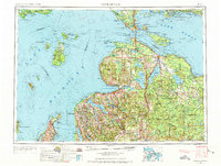
1955 Map of Cheboygan
USGS Topo · Published 1973About this map
Beaver Island and its remote settlement of St James anchor the western waters of this mid-century maritime landscape, where the northern Lower Peninsula meets the Upper Peninsula at the Straits of Mackinac. The region's transition from a timber-based economy to a recreation and transport hub is evident in the sprawling boundaries of the Pigeon River State Forest and Mackinac State Forest. Major inland waterways like Burt Lake and Mullett Lake are shown alongside the early infrastructure of the Penn Central and Detroit & Mackinac RR rail lines. From the coastal ports of Petoskey and Cheboygan to the isolated shores of North Manitou Island, the map captures the extensive network of state forests and the complex shoreline of Lake Michigan and Lake Huron before modern highway expansions fully reshaped the interior.
Find a feature on this map
192 named features on this map. Tap any name to fly to it.
Don’t see what you’re looking for? This feature index may not catch every label — zoom into the map to look around manually.
Map Details
Editions of this 1955 Cheboygan Map
5 editions found

Other maps of this area

1931 · St Ignace NW
USGS Topo · 1:31,680

1931 · Pickford SE
USGS Topo · 1:31,680

1931 · Epoufette SE
USGS Topo · 1:31,680

1931 · Seul Choix Point NE
USGS Topo · 1:31,680

1931 · Moran NE
USGS Topo · 1:31,680

1931 · Epoufette SW
USGS Topo · 1:31,680

1931 · Seul Choix Point NW
USGS Topo · 1:31,680

1931 · Manistique River SE
USGS Topo · 1:31,680

1931 · Blaney SW
USGS Topo · 1:31,680

1931 · Gould City SE
USGS Topo · 1:31,680