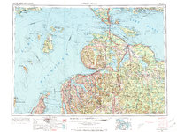
1955 Map of Cheboygan
USGS Topo · Published 1973About this map
The Straits of Mackinac anchor this mid-century topographic study, serving as the nexus between Lake Michigan and Lake Huron. The map details the intricate coastlines and island chains of Northern Michigan, including the remote Beaver Island and its Beaver Island Indian Reservation. Regional connectivity is defined by established transportation corridors like the Pennsylvania RR and New York Central RR, which linked coastal hubs such as Mackinaw City, Cheboygan, and Petoskey to the interior.
Find a feature on this map
257 named features on this map. Tap any name to fly to it.
Don’t see what you’re looking for? This feature index may not catch every label — zoom into the map to look around manually.
Map Details
Editions of this 1955 Cheboygan Map
5 editions found

Other maps of this area

1931 · St Ignace NW
USGS Topo · 1:31,680

1931 · Pickford SE
USGS Topo · 1:31,680

1931 · Epoufette SE
USGS Topo · 1:31,680

1931 · Seul Choix Point NE
USGS Topo · 1:31,680

1931 · Moran NE
USGS Topo · 1:31,680

1931 · Epoufette SW
USGS Topo · 1:31,680

1931 · Seul Choix Point NW
USGS Topo · 1:31,680

1931 · Manistique River SE
USGS Topo · 1:31,680

1931 · Blaney SW
USGS Topo · 1:31,680

1931 · Gould City SE
USGS Topo · 1:31,680