
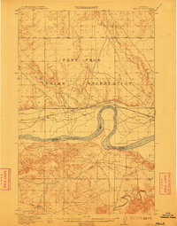
1912 Map of Chelsea
USGS Topo · Published 1912About this map
The Fort Peck Indian Reservation dominates the northern landscape of this 1912 survey, where the wide meanders of the Missouri River define the southern reaches. Along the northern bank, the Great Northern railroad provides a vital link for the settlement of Chelsea, while the southern terrain is marked by the drainages of Nickwall Creek and Redwater Creek. The map documents a period of transition as the survey by the General Land Office and the Missouri River Commission captures the precise Boundary Line between Valley and Dawson counties. Small outposts like Nickwall and Burch are situated among the coulees and upland benches, illustrating the sparse but strategic settlement patterns of northeastern Montana before later irrigation and dam projects altered the river's character.
Find a feature on this map
12 named features on this map. Tap any name to fly to it.
Don’t see what you’re looking for? This feature index may not catch every label — zoom into the map to look around manually.
Map Details
Editions of this 1912 Chelsea Map
2 editions found
Other maps of this area

1910 · Cuskers
USGS Topo · 1:62,500

1912 · Hay Creek
USGS Topo · 1:62,500

1912 · Poplar
USGS Topo · 1:62,500

1915 · Tule Valley
USGS Topo · 1:62,500

1915 · Cuskers
USGS Topo · 1:62,500

1916 · Wolf Point
USGS Topo · 1:62,500

1954 · Glendive
USGS Topo · 1:250,000

1954 · Wolf Point
USGS Topo · 1:250,000

1957 · Glendive
USGS Topo · 1:250,000

1958 · Wolf Point
USGS Topo · 1:250,000