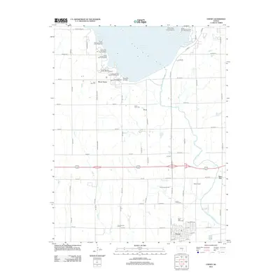
2012 Map of Cheney
USGS Topo · Published 2012About this map
The N Fork Ninnescah River anchors this landscape in south-central Kansas, feeding into the massive Cheney Reservoir which dominates the northern half of the region. The area around the reservoir is heavily developed for recreation, featuring numerous dedicated sites such as Cheney State Park Sailboat Cove Campground and the Cheney State Park West Boat Ramp. To the south, the city of Cheney serves as a local hub, with its street grid including Santa Fe and the Cheney Pioneer Cem.
Find a feature on this map
70 named features on this map. Tap any name to fly to it.
Don’t see what you’re looking for? This feature index may not catch every label — zoom into the map to look around manually.
Map Details
Editions of this 2012 Cheney Map
This is the sole edition of this map. No revisions or reprints were ever made.
Other maps of this area

1889 · Cheney
USGS Topo · 1:125,000

1891 · Cheney
USGS Topo · 1:125,000

1901 · Cheney
USGS Topo · 1:125,000

1955 · Wichita
USGS Topo · 1:250,000

1958 · Wichita
USGS Topo · 1:250,000

1959 · Mount Hope
USGS Topo · 1:24,000

1964 · Cheney
USGS Topo · 1:24,000

1965 · Garden Plain
USGS Topo · 1:24,000

1965 · Cheney SE
USGS Topo · 1:24,000
1965 · Waterloo
USGS Topo · 1:24,000