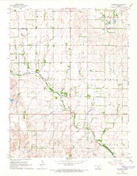
1965 Map of Waterloo
USGS Topo · Published 1966About this map
Waterloo sits at the heart of this mid-1960s Kansas landscape, serving as a focal point for the surrounding agricultural townships of Galesburg, Evan, and Dale. The survey captures a moment when the rural landscape was defined by the winding course of Smoots Creek and a network of section-line roads. Local history and genealogy are anchored by several established burial grounds, including Waterloo Cem, the St Louis Cem, and the more northern Lebanon Cem.
Find a feature on this map
18 named features on this map. Tap any name to fly to it.
Don’t see what you’re looking for? This feature index may not catch every label — zoom into the map to look around manually.
Map Details
Editions of this 1965 Waterloo Map
2 editions found
Other maps of this area

1889 · Cheney
USGS Topo · 1:125,000

1891 · Cheney
USGS Topo · 1:125,000

1892 · Kingman
USGS Topo · 1:125,000

1894 · Kingman
USGS Topo · 1:125,000

1901 · Cheney
USGS Topo · 1:125,000

1955 · Wichita
USGS Topo · 1:250,000

1955 · Pratt
USGS Topo · 1:250,000

1958 · Wichita
USGS Topo · 1:250,000

1959 · Pratt
USGS Topo · 1:250,000

1964 · Cheney
USGS Topo · 1:24,000