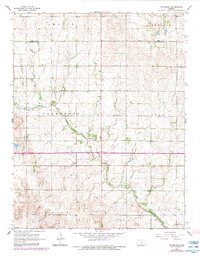
1965 Map of Waterloo
USGS Topo · Published 1983About this map
Waterloo and the small crossing at Midway anchor this landscape along the border of Reno and Kingman counties during the mid-1960s. The area is defined by the winding course of Smoots Creek, which cuts through the townships of Galesburg and Dale, while the waters of Spring Creek flow through the northern reaches of Albion. This survey documents a quiet rural economy where agriculture meets early energy development, evidenced by the Dewey Oil and Gas Field in the south and scattered gas wells to the west. Genealogists will find several burial sites preserved here, including St Louis Cem, Waterloo Cem, and Lebanon Cem. Transportation in the region is marked by the presence of the A T & S F railroad line, which skirts the southern edge of the survey near Vinita.
Find a feature on this map
18 named features on this map. Tap any name to fly to it.
Don’t see what you’re looking for? This feature index may not catch every label — zoom into the map to look around manually.
Map Details
Editions of this 1965 Waterloo Map
2 editions found
Other maps of this area

1889 · Cheney
USGS Topo · 1:125,000

1891 · Cheney
USGS Topo · 1:125,000

1892 · Kingman
USGS Topo · 1:125,000

1894 · Kingman
USGS Topo · 1:125,000

1901 · Cheney
USGS Topo · 1:125,000

1955 · Wichita
USGS Topo · 1:250,000

1955 · Pratt
USGS Topo · 1:250,000

1958 · Wichita
USGS Topo · 1:250,000

1959 · Pratt
USGS Topo · 1:250,000

1964 · Cheney
USGS Topo · 1:24,000