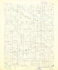
1889 Map of Cheney
USGS Topo · Published 1889About this map
The Arkansas River carves a broad valley across the northern reaches of this territory, setting the stage for a late-nineteenth-century agricultural landscape defined by rigid section lines and emerging rail hubs. Settled under the direction of J.W. Powell, the region shows a dense network of post offices and small rail stops that served as vital lifelines for farming families. Significant rail infrastructure, including the St. Louis and San Francisco Railroad and the Wichita and Western Railroad, dictated the growth of towns like Cheney and Garden Plain. Genealogists will find interest in the numerous rural post offices such as Stella P.O. and Mona P.O., which represent local community centers often lost to later consolidation. The map also traces the winding course of the North Fork Ninnescah River as it traverses the central plains, providing a detailed look at the natural drainage and early water management of the Kansas prairie.
Find a feature on this map
80 named features on this map. Tap any name to fly to it.
Don’t see what you’re looking for? This feature index may not catch every label — zoom into the map to look around manually.
Map Details
Editions of this 1889 Cheney Map
2 editions found
Other maps of this area

1889 · Newton
USGS Topo · 1:125,000

1889 · Anthony
USGS Topo · 1:125,000

1889 · Cheney
USGS Topo · 1:125,000

1889 · Wichita
USGS Topo · 1:125,000

1889 · Caldwell
USGS Topo · 1:125,000

1890 · Wellington
USGS Topo · 1:125,000

1891 · Hutchinson
USGS Topo · 1:125,000

1891 · Cheney
USGS Topo · 1:125,000

1891 · Anthony
USGS Topo · 1:125,000

1892 · Kingman
USGS Topo · 1:125,000