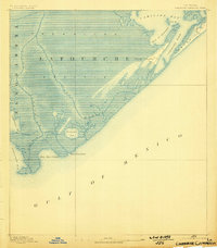
1892 Map of Cheniere Caminada
USGS Topo · Published 1898About this map
Cheniere Caminada and the western tip of Grand Isle define this late nineteenth-century coastal landscape, showing the region just prior to the catastrophic 1893 hurricane. The map documents the intricate network of waterways where the Bayou Lafourche and Bayou Moreau meet the Gulf of Mexico. This survey captures the fragile geography of the Trembling Prairie, an area characterized by its low elevation and fluid boundaries between land and sea. Along the coast, significant maritime passages like Caminada Pass, Pass Fourchon, and Belle Pass provide insight into the historic navigation routes used by local fishing and trapping communities. Small inland water bodies such as Champagne Bay and Bay St Honore dot the marshland, illustrating the complex deltaic environment before modern coastal erosion significantly altered these shorelines.
Find a feature on this map
16 named features on this map. Tap any name to fly to it.
Don’t see what you’re looking for? This feature index may not catch every label — zoom into the map to look around manually.
Map Details
Editions of this 1892 Cheniere Caminada Map
4 editions found
Other maps of this area

1892 · Cheniere Caminada
USGS Topo · 1:62,500

1892 · Creole
USGS Topo · 1:62,500

1893 · Fort Livingston
USGS Topo · 1:62,500

1894 · Timbalier
USGS Topo · 1:62,500

1894 · Lake Felicity
USGS Topo · 1:62,500

1935 · Bay Courant
USGS Topo · 1:31,680

1935 · Pelican Pass
USGS Topo · 1:31,680

1935 · Mink Bayou
USGS Topo · 1:31,680

1935 · Calumet Island
USGS Topo · 1:31,680

1935 · Leeville
USGS Topo · 1:31,680