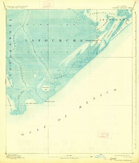
1892 Map of Cheniere Caminada
USGS Topo · Published 1927About this map
Cheniere Caminada and the surrounding marshlands appear here just before the devastating hurricane of 1893 forever changed the coastline. This survey, compiled from work by the U. S. Coast and Geodetic Survey, documents the complex hydrological network of the Lafourche and Jefferson parish border. The landscape is dominated by the Trembling Prairie, a name reflecting the unstable, water-saturated marsh typical of this region. Essential maritime passages like Caminada Pass and Pass Fourchon are clearly delineated, showing the natural inlets that provided access from the Gulf of Mexico to the inland Caminada Bay. On the eastern edge, the early configuration of Grand Isle is visible, separated from the mainland by narrow channels. The map captures the fragile geography of the deltaic plain, including the courses of Bayou Lafourche and Bayou Moreau as they meander toward the sea.
Find a feature on this map
18 named features on this map. Tap any name to fly to it.
Don’t see what you’re looking for? This feature index may not catch every label — zoom into the map to look around manually.
Map Details
Editions of this 1892 Cheniere Caminada Map
4 editions found
Other maps of this area

1892 · Cheniere Caminada
USGS Topo · 1:62,500

1892 · Creole
USGS Topo · 1:62,500

1893 · Fort Livingston
USGS Topo · 1:62,500

1894 · Timbalier
USGS Topo · 1:62,500

1894 · Lake Felicity
USGS Topo · 1:62,500

1935 · Bay Courant
USGS Topo · 1:31,680

1935 · Pelican Pass
USGS Topo · 1:31,680

1935 · Mink Bayou
USGS Topo · 1:31,680

1935 · Calumet Island
USGS Topo · 1:31,680

1935 · Leeville
USGS Topo · 1:31,680