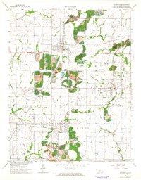
1964 Map of Cherokee
USGS Topo · Published 1965About this map
The Crawford and Cherokee county line bisects a landscape defined by intensive coal extraction in the mid-1960s. Extensive Strip Mine operations dominate the topography between the primary settlements of Cherokee and Weir, leaving a distinctive pattern of surface disturbance across the southeastern Kansas prairie. These industrial zones are framed by a dense network of transit, with the St Louis-San Francisco and Missouri Pacific railroads navigating through smaller communities like Scammon, Roseland, and Carona.
Find a feature on this map
27 named features on this map. Tap any name to fly to it.
Don’t see what you’re looking for? This feature index may not catch every label — zoom into the map to look around manually.
Map Details
Editions of this 1964 Cherokee Map
This is the sole edition of this map. No revisions or reprints were ever made.
Other maps of this area

1886 · Joplin
USGS Topo · 1:125,000

1894 · Joplin
USGS Topo · 1:125,000

1918 · Columbus
USGS Topo · 1:62,500

1943 · Cherokee
USGS Topo · 1:62,500

1945 · Pittsburg
USGS Topo · 1:62,500

1945 · Cherokee
USGS Topo · 1:62,500

1947 · Joplin
USGS Topo · 1:250,000

1947 · Pittsburg
USGS Topo · 1:62,500

1949 · Joplin
USGS Topo · 1:250,000

1950 · Pittsburg
USGS Topo · 1:62,500