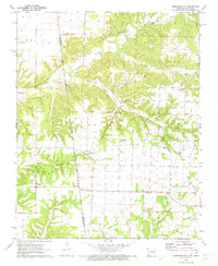
1971 Map of Cherokee City
USGS Topo · Published 1973About this map
The Old Indian Treaty Boundary carves a diagonal line through this 1971 landscape, marking a historical division between Arkansas and Oklahoma territories. This borderland region is defined by the rural settlements of Cherokee City and Bloomfield, where family and community history is anchored by numerous small burial grounds including Bloomfield Cem, Bozarth Cem, and Callum Cem. The terrain is shaped by the winding course of Spavinaw Creek and its many tributaries, such as Coon Creek and Cherokee Creek, which have carved deep drainages like Columbia Hollow. Local industry and infrastructure are represented by a Quarry and a Gaging Station on the creek, while the presence of the Benton Co Delaware Co line underscores the map's role in documenting the jurisdictional edges of the Ozark plateau at the start of the 1970s.
Find a feature on this map
25 named features on this map. Tap any name to fly to it.
Don’t see what you’re looking for? This feature index may not catch every label — zoom into the map to look around manually.
Map Details
Editions of this 1971 Cherokee City Map
2 editions found
Other maps of this area

1899 · Fayetteville
USGS Topo · 1:125,000

1899 · Siloam Springs
USGS Topo · 1:125,000

1901 · Fayetteville
USGS Topo · 1:125,000

1903 · Siloam Springs
USGS Topo · 1:125,000

1904 · Siloam Springs
USGS Topo · 1:125,000

1904 · Fayetteville
USGS Topo · 1:125,000

1954 · Tulsa
USGS Topo · 1:250,000

1958 · Tulsa
USGS Topo · 1:250,000

1963 · Tulsa
USGS Topo · 1:250,000

1970 · Gallatin
USGS Topo · 1:24,000