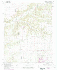
1971 Map of Cherokee City
USGS Topo · Published 1982About this map
The Indian Treaty Boundary cuts a definitive line through this borderland, separating the Arkansas counties from the Oklahoma frontier. This 1971 survey highlights the rural community of Cherokee City and the neighboring settlement of Bloomfield, documenting a landscape defined by small-scale agriculture and tributary waters like Cherokee Creek and Little Flint Creek. The northern reaches are more topographically varied, with the deep cuts of Columbia Hollow and Becker Hollow leading toward the winding course of Spavinaw Creek. Scattered family cemeteries such as Coats Cem, Dixon Cem, and Bozarth Cem are preserved here, providing essential data for genealogical research. The presence of the Kansas City Southern rail line near the town of Gentry on the eastern edge illustrates the era's transport infrastructure, while industrial activity is noted at the nearby Quarry and Pit.
Find a feature on this map
28 named features on this map. Tap any name to fly to it.
Don’t see what you’re looking for? This feature index may not catch every label — zoom into the map to look around manually.
Map Details
Editions of this 1971 Cherokee City Map
2 editions found
Other maps of this area

1899 · Fayetteville
USGS Topo · 1:125,000

1899 · Siloam Springs
USGS Topo · 1:125,000

1901 · Fayetteville
USGS Topo · 1:125,000

1903 · Siloam Springs
USGS Topo · 1:125,000

1904 · Siloam Springs
USGS Topo · 1:125,000

1904 · Fayetteville
USGS Topo · 1:125,000

1954 · Tulsa
USGS Topo · 1:250,000

1958 · Tulsa
USGS Topo · 1:250,000

1963 · Tulsa
USGS Topo · 1:250,000

1970 · Gallatin
USGS Topo · 1:24,000