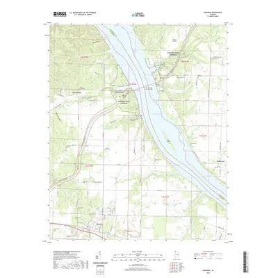
2020 Map of Cherokee
USGS Topo · Published 2020About this map
Cherokee serves as the primary southern anchor of this landscape, situated along the Old Lee Hwy and a rail line corridor. The terrain is defined by the broad waters of Pickwick Lake, which separates Colbert and Lauderdale counties and surrounds Kogers Island. Movement through the region is dominated by the Natchez Trace Pkwy, including the significant Natchez Trace Parkway Bridge crossing the river. This modern survey reveals a countryside dense with family and community history, evidenced by numerous burial grounds such as Thompson Cem, Malone Cem, and Good Hope Cem near Smithsonia. The land is dissected by complex drainage systems like Malone Cr and Colbert Cr, while smaller settlements such as Lane Springs and Georgetown are tucked into the valleys and hollows north of the main highway.
Find a feature on this map
90 named features on this map. Tap any name to fly to it.
Don’t see what you’re looking for? This feature index may not catch every label — zoom into the map to look around manually.
Map Details
Editions of this 2020 Cherokee Map
This is the sole edition of this map. No revisions or reprints were ever made.
Other maps of this area

1911 · Iuka
USGS Topo · 1:48,000

1914 · Iuka
USGS Topo · 1:62,500

1924 · Gravelly Springs
USGS Topo · 1:48,000

1925 · Barton
USGS Topo · 1:62,500

1926 · Barton
USGS Topo · 1:48,000

1926 · Gravelly Springs
USGS Topo · 1:62,500

1929 · Barton
USGS Topo · 1:62,500

1935 · Cherokee
USGS Topo · 1:24,000

1935 · Wright
USGS Topo · 1:24,000

1936 · Margerum
USGS Topo · 1:24,000