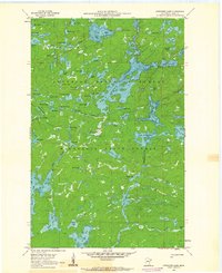
1960 Map of Cherokee Lake
USGS Topo · Published 1962About this map
Glacial water systems and dense woodlands dominate this landscape within the Superior National Forest and Minnesota State Forest. The intricate network of lakes, including the prominent Frost Lake and the winding Frost River, illustrates the complex hydrology of Cook County before modern development significantly altered these wilderness areas. Based on 1958 aerial photography and field-checked in 1960, this document reveals the specific contours of water bodies like Gunstock Lake, Town Lake, and the uniquely named Octopus Lake. The map identifies numerous smaller basins such as Squish Lake, Noodle Lake, and Guard Lake, providing a precise record of the shoreline and elevation data compiled by the Minnesota Department of Conservation. This survey serves as a vital point of reference for understanding the primitive state of the Iron Range region during the mid-twentieth century.
Find a feature on this map
75 named features on this map. Tap any name to fly to it.
Don’t see what you’re looking for? This feature index may not catch every label — zoom into the map to look around manually.
Map Details
Editions of this 1960 Cherokee Lake Map
3 editions found
Other maps of this area

1919 · Brule Lake
USGS Topo · 1:62,500

1954 · Two Harbors
USGS Topo · 1:250,000

1957 · Two Harbors
USGS Topo · 1:250,000

1957 · Quetico
USGS Topo · 1:250,000

1958 · Two Harbors
USGS Topo · 1:250,000

1959 · Gillis Lake
USGS Topo · 1:24,000

1960 · Tait Lake
USGS Topo · 1:24,000

1960 · Sawbill Camp
USGS Topo · 1:24,000

1960 · Brule Lake
USGS Topo · 1:24,000

1960 · Beth Lake
USGS Topo · 1:24,000