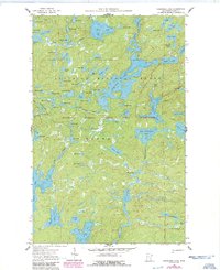
1960 Map of Cherokee Lake
USGS Topo · Published 1986About this map
Superior National Forest encompasses this intricate lacustrine landscape within the northern reaches of Cook County. The map details a labyrinth of glacial water bodies and interconnecting waterways, dominated by the expansive Frost Lake and the meandering Frost River. This 1960s-era documentation, updated with 1980s aerial data, highlights the preservation of the Boundary Waters Canoe Area Wilderness, where the absence of roads emphasizes a reliance on the historic Trails and portage routes that define this region. To the south, the Pat Bayle State Forest boundary marks a transition in land management. Smaller, descriptively named features like Bologna Lake, Noodle Lake, and Squish Lake reflect the vernacular of the surveyors and wilderness travelers who charted these remote sections of the Canadian Shield. The survey serves as a precise guide for tracing the unaltered shoreline of Gunflint Lake and Town Lake before modern recreational pressures intensified.
Find a feature on this map
80 named features on this map. Tap any name to fly to it.
Don’t see what you’re looking for? This feature index may not catch every label — zoom into the map to look around manually.
Map Details
Editions of this 1960 Cherokee Lake Map
3 editions found
Other maps of this area

1919 · Brule Lake
USGS Topo · 1:62,500

1954 · Two Harbors
USGS Topo · 1:250,000

1957 · Two Harbors
USGS Topo · 1:250,000

1957 · Quetico
USGS Topo · 1:250,000

1958 · Two Harbors
USGS Topo · 1:250,000

1959 · Gillis Lake
USGS Topo · 1:24,000

1960 · Tait Lake
USGS Topo · 1:24,000

1960 · Sawbill Camp
USGS Topo · 1:24,000

1960 · Brule Lake
USGS Topo · 1:24,000

1960 · Beth Lake
USGS Topo · 1:24,000