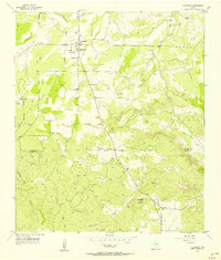
1956 Map of Cherokee
USGS Topo · Published 1956About this map
Cherokee serves as the primary hub on this mid-century survey, situated at the intersection of local routes near the northern edge of the map. To the south, the landscape transitions toward Babyhead Mountain and the settlement of Babyhead, where an indefinite boundary separates San Saba and Llano Counties. The area is defined by a dense network of seasonal drainages, including Cherokee Creek and Babyhead Creek, which feed toward the Little Llano River in the east. Genealogy and local history researchers will find several family and community landmarks, such as Kuykendall Cem and Hanna Cem. A notable point of transition is visible at the Babyhead Sch (Aband), reflecting shifts in rural education as local centers of activity consolidated toward the High Sch in Cherokee.
Find a feature on this map
22 named features on this map. Tap any name to fly to it.
Don’t see what you’re looking for? This feature index may not catch every label — zoom into the map to look around manually.
Map Details
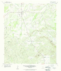
Editions of this 1956 Cherokee Map
2 editions found
Other maps of this area

1885 · San Saba
USGS Topo · 1:125,000

1887 · Llano
USGS Topo · 1:125,000

1894 · San Saba
USGS Topo · 1:125,000

1894 · Llano
USGS Topo · 1:125,000

1904 · Llano
USGS Topo · 1:125,000

1909 · Llano
USGS Topo · 1:125,000

1918 · Llano
USGS Topo · 1:125,000

1931 · Bend
USGS Topo · 1:62,500

1954 · Brownwood
USGS Topo · 1:250,000

1954 · Llano
USGS Topo · 1:250,000