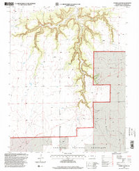
1996 Map of Cherry Canyon
USGS Topo · Published 2000About this map
The Santa Fe Historic National Route of the Granada Fort Union cuts across the southern reach of this landscape, marking a legacy of nineteenth-century western migration and trade. This corridor connects the high plains of the Comanche National Grassland with the deep incisions of the surrounding canyon systems. The topography is defined by the branching network of Cherry Canyon and its tributaries, including Soldier Canyon, Smith Canyon, and Snake Canyon. These features illustrate the dramatic erosion patterns typical of Las Animas County, where drainage systems like Plum Valley provided critical routes and resources for early travelers and ranchers. This 1990s revision reflects the preserved state of the grassland and the enduring presence of these natural landmarks.
Find a feature on this map
9 named features on this map. Tap any name to fly to it.
Don’t see what you’re looking for? This feature index may not catch every label — zoom into the map to look around manually.
Map Details
Editions of this 1996 Cherry Canyon Map
This is the sole edition of this map. No revisions or reprints were ever made.
Other maps of this area

1891 · Mesa De Maya
USGS Topo · 1:125,000

1892 · Mt Carrizo
USGS Topo · 1:125,000

1893 · Mesa de Maya
USGS Topo · 1:125,000

1955 · La Junta
USGS Topo · 1:250,000

1958 · La Junta
USGS Topo · 1:250,000

1968 · La Junta
USGS Topo · 1:250,000

1972 · Plum Canyon
USGS Topo · 1:24,000

1972 · Tobe
USGS Topo · 1:24,000
1972 · Villegreen
USGS Topo · 1:24,000
1978 · Dalerose Mesa
USGS Topo · 1:24,000