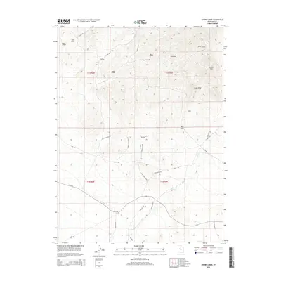
2014 Map of Cherry Creek
USGS Topo · Published 2014About this map
Sheeprock Mountains define the northern terrain of this section of Juab County, giving way to a complex system of drainages and named hollows. The landscape is characterized by its hydrological features and historical ranching corridors, with Cherry Crk and Indian Springs providing critical water sources in an otherwise arid environment. Evidence of land use and navigation is found in the network of rural roads such as Rockwell Rnch and Weiss Hwy, which cut through the lower elevations and connect dispersed points of interest like Chicken Rock. Genealogists and local historians can trace the paths of long-standing infrastructure, including Telephone Rd and Trail Rd, which follow natural contours through Great Eastern Hollow and Scotia Gulch. The map illustrates a region where topography dictated the placement of early routes and homesteads.
Find a feature on this map
35 named features on this map. Tap any name to fly to it.
Don’t see what you’re looking for? This feature index may not catch every label — zoom into the map to look around manually.
Map Details
Editions of this 2014 Cherry Creek Map
This is the sole edition of this map. No revisions or reprints were ever made.
Other maps of this area

1885 · Sevier Desert
USGS Topo · 1:250,000

1953 · Delta
USGS Topo · 1:250,000

1958 · Delta
USGS Topo · 1:250,000

1962 · Delta
USGS Topo · 1:250,000

1962 · Lynndyl
USGS Topo · 1:62,500

1963 · Maple Peak
USGS Topo · 1:24,000
1963 · Sabie Mountain
USGS Topo · 1:24,000

1963 · Dutch Peak
USGS Topo · 1:24,000

1963 · Cherry Creek
USGS Topo · 1:24,000
1971 · Erickson Knoll
USGS Topo · 1:24,000