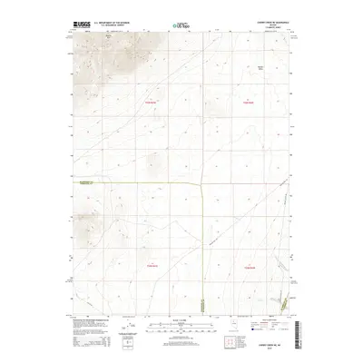
2014 Map of Cherry Creek NE
USGS Topo · Published 2014About this map
Buffalo Mtn dominates the northwestern corner of this Nevada landscape, where the high elevations of the range descend into the broad expanse of Buffalo Valley. The geography is defined by the meeting of three counties—Humboldt, Pershing, and Lander—marked by straight-line jurisdictional boundaries that bisect the arid terrain. Natural drainage follows narrow corridors like Trenton Cr and Mill Creek in the southeast, providing rare water sources in a region characterized by wide basins and steep ridges. Transportation through this remote section of the Great Basin relies on a network of unpaved routes, including Smelser Pass Rd and Buffalo Valley Rd, which navigate the gaps between the mountains. The map also shows a segment of Nv-93-Alt cutting across the southwestern corner, illustrating how modern infrastructure skirts the edges of these high-desert obstacles.
Find a feature on this map
15 named features on this map. Tap any name to fly to it.
Don’t see what you’re looking for? This feature index may not catch every label — zoom into the map to look around manually.
Map Details
Editions of this 2014 Cherry Creek NE Map
This is the sole edition of this map. No revisions or reprints were ever made.
Other maps of this area

1932 · Sonoma Range
USGS Topo · 1:250,000

1939 · Sonoma Range
USGS Topo · 1:250,000

1940 · Antler Peak
USGS Topo · 1:62,500

1943 · Antler Peak
USGS Topo · 1:62,500

1955 · Winnemucca
USGS Topo · 1:250,000

1958 · Winnemucca
USGS Topo · 1:250,000

1962 · Winnemucca
USGS Topo · 1:250,000

1965 · Goldrun Creek
USGS Topo · 1:24,000

1965 · Edna Mountain
USGS Topo · 1:62,500
1965 · Brooks Spring
USGS Topo · 1:24,000