
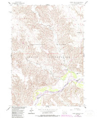
1956 Map of Cherry Creek NW
USGS Topo · Published 1957About this map
The Cheyenne River winds through this mid-century South Dakota landscape, defining the physical and political boundaries of the region. This 1956 survey, conducted as part of the Department of the Interior program for the development of the Missouri River Basin, reveals the sparse settlement patterns along the river valley and the neighboring heights. The map documents the Indian Reservation Boundary as it intersects the river, while prominent landmarks like Joshua Butte rise above the drainage systems of Cottonwood Creek and Little Cottonwood Creek. Local cattle ranching operations are anchored at named sites such as Red Fox Ranch, Motley Ranch, and White Cloud Ranch, which serve as the primary human identifiers in this open country. The transition from the high plains down to the riparian zones of Deep Creek and the main river channel is captured through detailed 20-foot contour intervals, illustrating the drainage network before further regional infrastructure developments changed the local character.
Find a feature on this map
10 named features on this map. Tap any name to fly to it.
Don’t see what you’re looking for? This feature index may not catch every label — zoom into the map to look around manually.
Map Details
Editions of this 1956 Cherry Creek NW Map
2 editions found
Other maps of this area

1954 · Pierre
USGS Topo · 1:250,000

1955 · Rattlesnake Lake SE
USGS Topo · 1:24,000

1955 · Rattlesnake Lake NE
USGS Topo · 1:24,000

1956 · Kirley
USGS Topo · 1:24,000

1956 · Carlin Flat
USGS Topo · 1:24,000

1956 · Cherry Creek
USGS Topo · 1:24,000

1958 · Pierre
USGS Topo · 1:250,000

1981 · High Elk Hill SE
USGS Topo · 1:24,000

1981 · High Elk Hill SW
USGS Topo · 1:24,000
1982 · Sears Dam
USGS Topo · 1:24,000