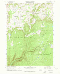
1970 Map of Cherry Flats
USGS Topo · Published 1972About this map
The Welsh Settlement community defines the northern uplands of this 1970 landscape, where the Welsh Settlement Ch and Welsh Settlement Cem stand as markers of a specific immigrant history in Tioga County. To the east, the village of Cherry Flats sits at a crossroads below Maple Hill, while the southern portion of the quadrangle is dominated by the dense terrain of the Tioga State Forest. Industrial imprints are visible through several Strip Mines and a Mine Dump scattered across the ridges. Evidence of the region’s earlier timber and coal economy is preserved in the form of the Old Railroad Grade winding through the valleys of Lick Run and Babb Creek. Near the southern boundary, the small settlement of Landrus remains connected by a network of unimproved roads and trails, including a remote Landing Strip carved into the high ground near Dyke Run.
Find a feature on this map
33 named features on this map. Tap any name to fly to it.
Don’t see what you’re looking for? This feature index may not catch every label — zoom into the map to look around manually.
Map Details
Editions of this 1970 Cherry Flats Map
3 editions found
Other maps of this area

1900 · Tioga
USGS Topo · 1:62,500

1900 · Elkland
USGS Topo · 1:62,500

1902 · Tioga
USGS Topo · 1:62,500

1925 · Blossburg
USGS Topo · 1:62,500

1927 · Blossburg
USGS Topo · 1:62,500

1944 · Blossburg
USGS Topo · 1:62,500

1946 · Antrim
USGS Topo · 1:62,500

1946 · Antrim
USGS Topo · 1:24,000

1946 · Morris
USGS Topo · 1:24,000

1948 · Antrim
USGS Topo · 1:24,000
Featured Places
- Morris Township, PA
- Duncan Township, PA
- Bloss Township, PA
- Cherry Flats, Covington Township
- Liberty Township, PA