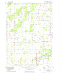
1974 Map of Chesaning West
USGS Topo · Published 1978About this map
The Shiawassee River and Bad River drain this agricultural portion of the Saginaw Valley in the mid-1970s. The village of Oakley serves as a local hub near the southern border, while the larger settlement of Chesaning anchors the eastern edge, supported by the Chesaning Airport and the Conrail railroad line. The landscape is characterized by a dense grid of rural roads like Ferden Road and Marion Road, interspersed with numerous gravel pits and sandpits that point to the region's glacial geology and local industry. Genealogists will find several burial grounds documented, including Wildwood Cem and Oak Grove Cem. Small historical centers like Brady Center and the dual-named Parshallburg (Havana) provide specific points of interest for those tracing family roots or the evolution of small-town Michigan before modern sprawl altered the character of these rural townships.
Find a feature on this map
43 named features on this map. Tap any name to fly to it.
Don’t see what you’re looking for? This feature index may not catch every label — zoom into the map to look around manually.
Map Details
Editions of this 1974 Chesaning West Map
This is the sole edition of this map. No revisions or reprints were ever made.
Other maps of this area

1917 · Chesaning
USGS Topo · 1:62,500

1917 · St. Charles
USGS Topo · 1:62,500

1918 · Elsie
USGS Topo · 1:62,500

1934 · Merrill
USGS Topo · 1:62,500

1937 · Merrill
USGS Topo · 1:62,500

1943 · Chesaning
USGS Topo · 1:62,500

1943 · St. Charles
USGS Topo · 1:62,500

1943 · Elsie
USGS Topo · 1:62,500

1954 · Midland
USGS Topo · 1:250,000

1958 · Midland
USGS Topo · 1:250,000