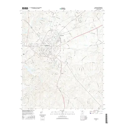
2017 Map of Chester
USGS Topo · Published 2017About this map
Chester serves as the focal point of this Piedmont landscape, shown here as a regional hub defined by its textile heritage and rail connections. The industrial character of the era is evident in the presence of Eureka Mill, Gayle Mill, and the settlement at Orrs, while the L & C RR provides the primary transit corridor through the center of town. For those researching local family history, several prominent burial grounds are documented, including Evergreen Cem and the centrally located Old Purity Cem. The surrounding terrain is drained by a dense network of waterways such as the Sandy River and Rocky Cr, with the southwestern quadrant preserved as Chester State Park. This survey captures the town's transition from a mill-driven economy to a modern county seat, maintaining its traditional layout around the courthouse district.
Find a feature on this map
122 named features on this map. Tap any name to fly to it.
Don’t see what you’re looking for? This feature index may not catch every label — zoom into the map to look around manually.
Map Details
Editions of this 2017 Chester Map
This is the sole edition of this map. No revisions or reprints were ever made.
Other maps of this area

1907 · Sharon
USGS Topo · 1:62,500

1941 · Spartanburg
USGS Topo · 1:250,000

1949 · Rock Hill
USGS Topo · 1:62,500

1953 · Spartanburg
USGS Topo · 1:250,000

1960 · Spartanburg
USGS Topo · 1:250,000

1963 · Spartanburg
USGS Topo · 1:250,000

1964 · Spartanburg
USGS Topo · 1:250,000

1968 · Blackstock
USGS Topo · 1:24,000
1969 · Stover
USGS Topo · 1:24,000
1969 · Richburg
USGS Topo · 1:24,000