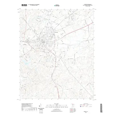
2020 Map of Chester
USGS Topo · Published 2020About this map
Chester serves as the focal point of this Piedmont region survey, anchored by the Chester County Courthouse and a surrounding network of historical mill communities. The industrial legacy of the area is evident in the locations of Gayle Mill to the southwest and Eureka Mill to the northeast, while the settlement of Orrs marks the eastern edge. This landscape is deeply etched by a complex drainage system including the Little Sandy River, Sandy River, and Rocky Cr, which have shaped the local topography for generations.
Find a feature on this map
114 named features on this map. Tap any name to fly to it.
Don’t see what you’re looking for? This feature index may not catch every label — zoom into the map to look around manually.
Map Details
Editions of this 2020 Chester Map
This is the sole edition of this map. No revisions or reprints were ever made.
Other maps of this area

1907 · Sharon
USGS Topo · 1:62,500

1941 · Spartanburg
USGS Topo · 1:250,000

1949 · Rock Hill
USGS Topo · 1:62,500

1953 · Spartanburg
USGS Topo · 1:250,000

1960 · Spartanburg
USGS Topo · 1:250,000

1963 · Spartanburg
USGS Topo · 1:250,000

1964 · Spartanburg
USGS Topo · 1:250,000

1968 · Blackstock
USGS Topo · 1:24,000
1969 · Stover
USGS Topo · 1:24,000
1969 · Richburg
USGS Topo · 1:24,000